
NYC DOT plan adds bike lanes, keeps parking, and wants to cut out cut-through traffic.

Less than a month ago, McGuinness Boulevard ended its role as the dividing line that split NYS Assembly District 50 in two. (The finalized map of District 50 keeps Greenpoint whole.) Yet, the reveal of the NYC Department of Transportation (NYC DOT)’s new plan for a safer McGuinness Boulevard during May’s Brooklyn Community Board 1’s Transportation Committee meeting divided the community into those who were pleased and those who got road rage.
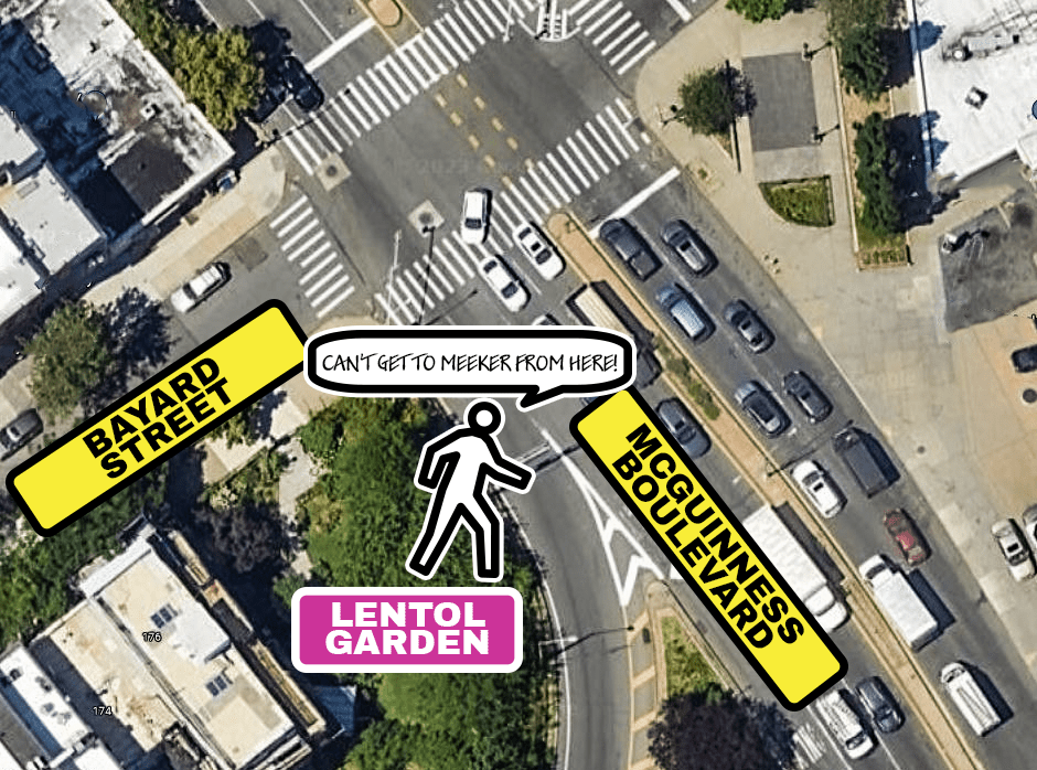
The pleased ones look forward to a road that doesn’t prime their heart to pump anxiety while crossing McGuinness Boulevard. This road’s danger has been well documented. 229 crashes with injuries happened on McGuinness between 2015 and 2019. Three people were killed within a ten-year span. Plans to make McGuinness Boulevard safer got a fast forward after Matthew Jensen, a beloved P.S. 110 school teacher and neighbor, was killed by a hit-and-run when crossing McGuinness at Bayard Street at night in 2021.
Those who were displeased communicated: that losing two driving lanes may make McGuinness safer but drivers will divert to other smaller side streets, which may increase the danger there. That it could harm local businesses by adding obstacles to truck traffic. That the added bike lanes won’t be utilized enough to justify them. That cyclists and pedestrians also have responsibilities and should obey the rules of the road.
As to that last point, according to the NYC DOT’s study, the most common pedestrian injuries occur when pedestrians are crossing with the signal. However, for the most part both sides had valid arguments.
The NYC DOT’s chosen plan for McGuinness received the most support out of the three choices they offered for this street’s new road diet plan. These options were discussed at: three community workshops from August to November of 2021; a Brooklyn Community Board 1’s Transportation Committee meeting on June 30, 2022; a town hall in November; NYC DOT Street Ambassador outreach (249 intersections, 403 comments); online feedback map (750+ comments); a merchant survey (46 businesses surveyed); and other meetings with businesses and safety advocates. Option B was selected and offered the removal of two driving lanes in exchange for more parking compared to the other two options. All three options had one or two travel lanes removed, but A’s two-lane removal was in the form of driving lanes being temporarily converted to off-peak parking, but remaining driving lanes during peak travel periods.
One motivating factor in eliminating two of the driving lanes, according to the NYC DOT, is to reduce cut-through traffic. According to cell phone data, 30% of vehicles using McGuinness are vehicles that have no origination or destination point in the neighborhood.
The NYC DOT repeatedly stated the plan is a work in progress even when implemented. They would consistently monitor it as the transition happens, and they have the ability to make changes fairly quickly.
“[We will] keep tweaking it to make sense for everyone using it,” said Zack Wyche, asst. civil engineer for NYC DOT and project manager of McGuinness Boulevard’s redesign.
“My and all elected officials’ priority is safety. The DOT mentioned 229 crashes in five years, it’s about a crash per week. Just far too dangerous for people in our community and has been for as long as I can remember. I really believe this is a plan that sews our neighborhood back together,” said NYC Council Member Lincoln Restler.
NYS Assembly Member Emily Gallagher said, “I, for the last seventeen years, needed to cross McGuinness daily. I know the fear. I’ve seen accidents myself happen that were horrible. Right outside my first apartment someone was killed. Making sure we are prioritizing safety for all users of this road is really essential. I use the road in all fashions: car, bike, walk every day.”

Questions then came from BKCB1’s Transportation Committee members.
Mary Odomirok stated that McGuinness Boulevard is a designated evacuation emergency route during catastrophic emergencies. She asked to know what measures are in place to convert the road during such an event.
Wyche answered, “Turns out various agencies have moved away from that … use several routes upland, on higher ground, not just one. [McGuinness] will still operate.”
Gina Argento stated she’d like a new study with local traffic, as opposed to the 2019 study that focused on commuter traffic.
Wyche answered, “The study used to project the traffic change was conducted last fall [using cell phone data].” He added they will do constant monitoring to get newer data.
Gina Argento later asked for a list of businesses that were surveyed about the changes. She said it doesn’t seem that many are aware. In addition to being on BKCB1 she is the CEO of Broadway Stages.
Wyche said they only surveyed McGuinness Boulevard businesses
Keith Bray, Brooklyn borough commissioner of NYC DOT, added, “We have talked to Evergreen, we will speak to you after this to talk to other [businesses].
The meeting was then opened up to questions from the public.
Tony Argento, founder of Broadway Stages, said, “My company and clients are heavy truck users. If we can’t get our trucks to a location, what’s the point of being here? Total chaos. More studies [need to be] done.”
Karen Nieves, of Evergreen, said, “The huge concern I have is removing a lane of traffic and what those impacts will be to the community. Not only us but Long Island City.” She added she is concerned that the NYC DOT doesn’t have a mitigation plan, that Humboldt and Apollo streets are currently overburdened. “Businesses are worried about late deliveries — a lot of vendors don’t want to come here and that hurts the businesses,” she added.
Keith Bray replied that the DOT does have a pre-implementation plan, and that they will speak to Karen before they go to one lane in each direction.
Concerns about the elderly having longer walks to the bus stops were countered by Wyche who cited the 2022 Pedestrian Safety and Older NYers study, “On streets with protected bike lanes, seniors saw a 39% decrease in KSI (killed or severely injured) and a 22% drop in overall injuries. Non-senior adults saw a 24% drop in KSI and 9% drop in overall injuries.”
The McGuinness Boulevard feedback map is still accepting comments (as of this writing). Here is the link: https://nycdotprojects.info/project-feedback-map/feedback-map-locations-and-points. You can also view the comments of others on the map.

I don’t think removing a lane will make the boulevard any less dangerous. If it’s dangerous, we need to add speed bumps, more speed cameras… On Long Island there are towns where you get fined for driving past a YELLOW light – why don’t we implement that on McGuiness?
LikeLike